 Washington Trails Association
Trails for everyone, forever
When Mount St. Helens erupted, it left hundreds of square miles of what appeared to be a barren wasteland. Scientists thought nothing could have survived — and that life would take years to return. Life is resilient, however, and returned sooner than anyone could have imagined. And in the four decades since, life has continued to return in beautiful and surprising ways.
On May 18, 1980, people all over the world watched with awe and horror as Mount St. Helens erupted. Fifty-seven people were killed and hundreds of square miles of lush forests and wild rivers were to all appearances destroyed.
Ecologists thought they would have to wait years, or even decades, for life to return to the mountain, but just a few weeks after the eruptions, scientists found small plants bursting through the ash and animals skittering over the ground. Rather than being a dead zone, the mountain was very much alive.
Mount St. Helens has been surprising ecologists ever since. In his new book, “After the Blast,” author and WTA member Eric Wagner takes readers on a journey through the blast area and beyond, where ecologists were prompted to think in new ways about how life responds in the face of seemingly total devastation.
Keep reading for several excerpts from Eric’s book.
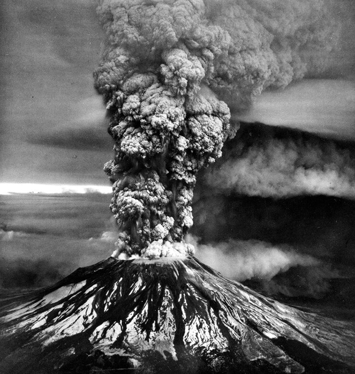
The story of the eruption of Mount St. Helens as most of us know it begins with two prepositions, at and on, usually in that order and in quick succession: at 8:32 a.m., on Sunday, May 18, 1980, a powerful earthquake shook the mountain. The summit rippled, churned, and then collapsed as more than 2 billion tons of rock, snow, and glacial ice fell away in the largest landslide recorded in human history.
The following eruption lasted nine hours and caused the deaths of 57 people. When it was over, Mount St. Helens was 1,314 feet shorter. Where the summit had been gaped a crater a mile wide and 2,000-feet deep. In a 180-degree arc to the north, 234 square miles of forest were buried, knocked flat, or left standing but scorched. As it was blown east, the towering plume of ash blocked out the sun for miles. The plume eventually climbed to the stratosphere and floated across the U.S., dusting 17 states. In 15 days it had circled the Earth.
Back in the blast area, the sense of desolation was greater than mere statistics could convey. Mount St. Helens had always been a perfect white cone, surrounded by dark forests and reflected in a deep, clear lake. In their place was a hollow volcano in a wrecked landscape of black and gray.
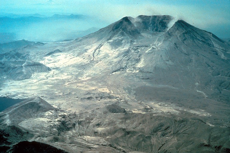
A couple of weeks after the eruption, on a bright morning in June, a helicopter lifted off from Vancouver, Washington, and headed toward the volcano. Riding in it were Jerry Franklin, Jim Sedell, and Fred Swanson. Franklin and Sedell were ecologists with the US Forest Service, and Swanson a geologist also with the agency.
The whup-whup of the helicopter’s rotors was so loud that it was impossible to hear anyone speak, but it did not matter, because no one had anything to say. The eruption had overwhelmed their professional vocabulary.
Franklin and Sedell were certain that nothing could have survived. Mount St. Helens had presented ecologists with what was in effect a huge natural experiment. It was as if the volcano itself had posed a question: What happens when every single living thing for hundreds of square miles, big and small, plant and animal, is burned away or buried, and nothing is left but rock and ash?
Franklin and Sedell had discussed the question at length. Their working hypothesis was that although it might take decades or even centuries, plants and animals were sure to return. Here then was an unprecedented opportunity to document how living things crept back in from the outside world, to test on the grandest of scales some of the oldest and most durable theories in ecology and evolution about how life responds to a massive disturbance.
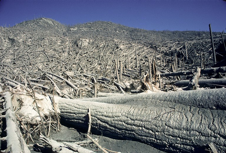
Fallen trees flattened during the lateral blast litter the blowdown zone near Mount St. Helens. After the blast, the landscape looked barren from a distance, but small signs of life soon began to return. Photograph by James Hughes, courtesy of U.S. Forest Service.
The helicopter neared the mountain and flew past the still-steaming crater. The pilot scanned the ground for a safe place to land, eventually settling close to Ryan Lake, about twelve miles distant. Franklin opened the helicopter’s side door and hopped out. His boots sent up little puffs of ash. He glanced down, but instead of the gray he expected, he saw a bit of green poking up. He knelt. It was a plant shoot, maybe two or three inches tall. “I’ll be damned,” Franklin thought. It was Chamaenerion angustifolium, a plant much more widely known by its common name, fireweed.
Fireweed is a common perennial plant with pink, red, or purple flowers. It can spread through the soil by means of a system of roots a few inches beneath the surface. The plant can regrow from as little as an inch or two of remnant root. The stalk grows quickly, up to one inch per day. Franklin considered this fireweed sprout so close to Mount St. Helens. It could not have come from a seed; fireweed would not set seed for a couple of months yet. It had to have come from a piece of root that had survived under all the ash and debris.
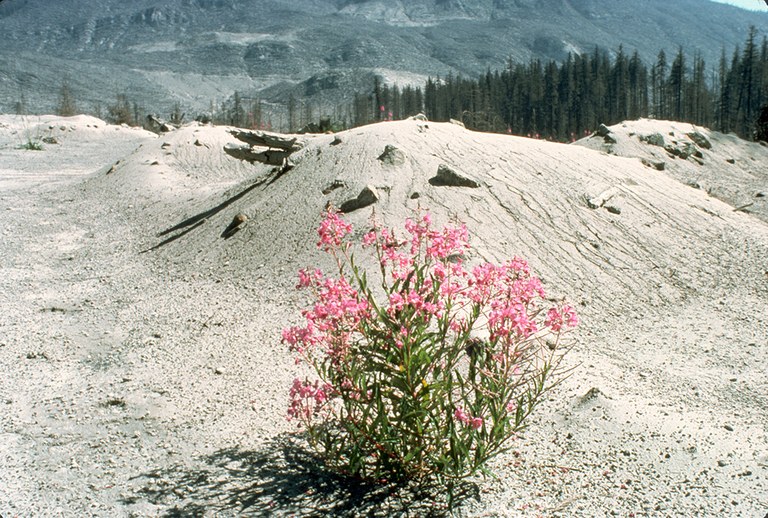
Franklin took in the landscape again. He realized that this fireweed was one of tens, hundreds, maybe even thousands of little green shoots emerging from the ash. He saw the beginnings of pearly everlasting and thistles. More than plants, he noticed evidence of other forms of life. Beetles were scuttling over the downed trees. Dark mounds of dirt showed where a pocket gopher must have pushed up from its subterranean tunnels. Roving herds of ungulates — elk, probably — had already planted prints in the ash as they picked their way through the tangle of trees.
Franklin clambered over the trunks—how hard it was to get around!—and stumbled toward a stream that was working its way through the ash to the old surface. The water was almost clear and a film of algae was starting to spread. He was astonished, elated. “Right off,” he said later, “all of us smart ecologists realized we didn’t have the correct working hypothesis.”
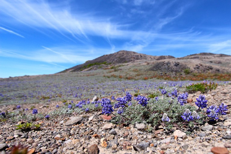
In 1981, Charlie Crisafulli and Jim MacMahon set out for the Pumice Plain to place a few transects. The two ecologists from Utah State University wanted to begin surveys for birds and small mammals. They hardly expected to find any. The results from their first surveys were what they anticipated — zeroes — but they continued the work the next year, and one day in June of 1982, when they were walking to one of their transects, they spotted a small patch of purple on the ground ahead.
“What’s that?” MacMahon said. He and Crisafulli crunched over the pumice toward it. They found a single adult prairie lupine, about 5 inches tall. A ring of seedlings surrounded it.
Crisafulli and MacMahon could hardly believe what they were seeing. The little group of flowers was small, about twelve inches in diameter, surrounded by pumice and dacite, a type of igneous rock. Making its presence even more astonishing, the lupine had to have been growing for at least a year to have produced seedlings. How had it made its way all the way out here, a lifeless area four miles from the crater? Had a bird eaten the seed and pooped it out while flying overhead? Transport aside, how had the seed managed to take root when there was no soil?
Without knowing the answers, Crisafulli and MacMahon did what came naturally: they documented their finding. The following spring, in 1983, they came back to the lupine and measured out a rectangle 168 square meters in area, with the plant at the center. They hammered a few stakes around the perimeter and then strung twine around the stakes to cordon off the founding plant so no one would step on it. It was the first vegetation plot on the Pumice Plain.
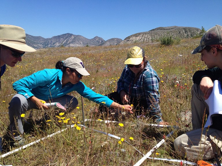
Cynthia Chang, a plant ecologist from the University of Washington at Bothell, steps lightly up the unsteady log ladder on the Abraham Trail, even with a backpack full of gear. With her is her student, Laurel Baum. She is taller than Chang, and her pace is steadier — more of a plod. The reason for that becomes clear when we reach the Plains of Abraham and Baum sets down her backpack. It settles on the ground with a solid clunk. Chang is immediately suspicious. “Laurel,” she asks, “what’s in there?”
“Nothing,” Baum says. Then she allows: “I brought along some of the extra rebar.”
“How much?”
A beat. “All of it.”
Chang is aghast. “All of it?” she says.
Baum shrugs.
“Like, all thirty pounds of it?”
Baum shrugs again. “I didn’t want you to have to carry it,” she says. With an almost apologetic air she begins to pull bundle after bundle of eighteen-inch-long rebar stakes from her backpack.
“Laurel, that’s way too much for you,” Chang says as the rebar piles up. “Please don’t do that again.” Then she grins. “Still, as long as we’ve got it all ... ”
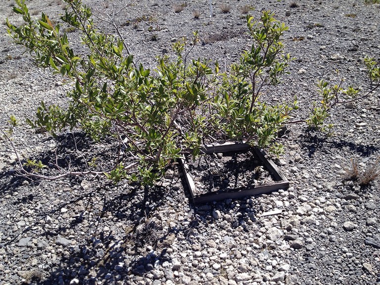
One of the original research plots Cynthia Chang was searching for in the Plains of Abraham. Photograph: Eric Wagner.
Chang has come to the Plains of Abraham today in search of a set of old research plots. She has their GPS coordinates, and she hopes that if she can find the plot boundaries, she can replace the old metal stakes with the new rebar stakes. But the coordinates are more approximate than she anticipated, and the old stakes not quite as durable. After a few hours, we have uncovered only a few. Chang is undaunted. “We’ll be back tomorrow,” she says to Baum, who is stashing the rest of the rebar next to a boulder. “We can come faster because we won’t be carrying so much.”
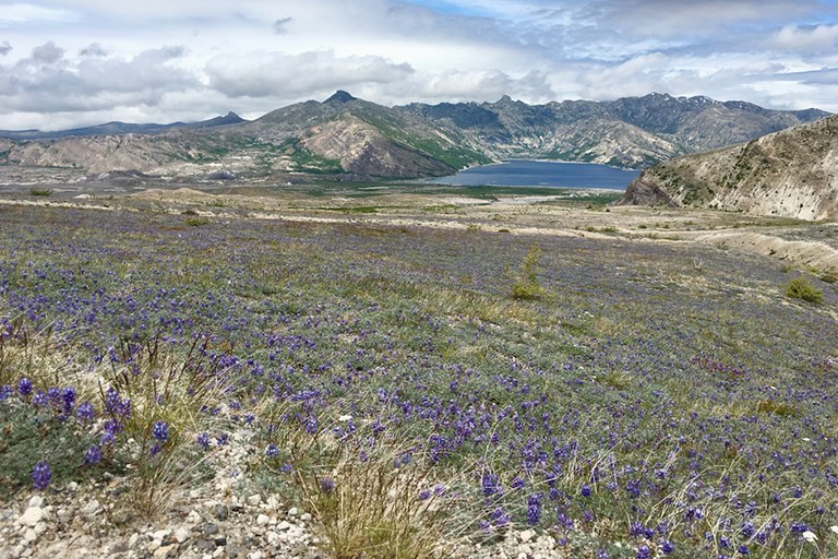
We decide to hike back to Windy Ridge by way of Windy Pass. Behind us lie the plains; before us extends the much larger Pumice Plain. Spirit Lake fronts it like a doormat, with the shorter, bare peaks of the Mount Margaret Backcountry beyond. I sit for a moment to catch my breath. Near my feet, a spray of prairie lupines shivers in the wind. I look up and see that they are shivering along with hundreds of their kin — no, thousands of them, cluster upon cluster of prairie lupines carpeting the hillside.
“Look at all the lupines,” I say.
“I know,” Chang says. “Pretty, aren’t they?”
“Yes.” Pretty, and also abrupt. This mass of lupines has marched all the way up to Windy Pass, but not over it. The line where they stop is so neatly demarcated that it does not seem biological but rather a border enforced by some other means. “Why haven’t they made it to the Plains of Abraham?” I ask.
“I’m not sure,” Chang says. “But you can see how well they’re doing here.”
From After the Blast: The Ecological Recovery of Mount St. Helens by Eric Wagner (University of Washington Press, 2020).
