Recently Viewed ›
Recently Downloaded 
Close x

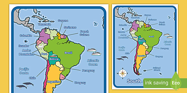
Engage your students in geography with our South America Map With Words and Pictures. This colourful map of South America is labelled with key places and related pictures. Print and display or distribute for practising geography skills.
 south america map
north and south america
map of south america
africa map
north america
central america
map of brazil
antarctica map
north america map
world map
map of europe
america
asia
south america map
north and south america
map of south america
africa map
north america
central america
map of brazil
antarctica map
north america map
world map
map of europe
america
asia
Engage your students in geography with our South America Map With Words and Pictures. This colourful map of South America is labelled with key places and related pictures. Print and display or distribute for practising geography skills.
This colourful South America Map display poster features the names of the 12 different countries, including Brazil, Paraguay and Chile. It is labelled with key places and related pictures. A handy reference when completing geography tasks, or celebrating South American culture.
However you choose to use it, this South American Map is perfect for a variety of different activities.
Try it out, and improve the geography knowledge of your classes.
You can print out the standard version, or the Super Eco Colour by heading over to the 'more downloads' section. If you don't like either version, you can request a different version. Then hit the download button, and have this great resource available to use in your classroom. Print it out and give it out to your students to stick in their books, or laminate it for multiple uses.
For more about South America, check out this South America Teaching Wiki.
Twinkl has lots of resources to assist both parents and teachers in helping students learn about South America and the different countries on the continent. Our readily available resources are here to support you and your students with all of their needs.
For some ideas on what to try out next, check out our list of recommended resources below:
What's more, all of our resources have been created with care by qualified teachers, so you can be certain that the learning material you are providing is high quality, accurate, and up to date.
Share your experience using this South American map resource or any other Twinkl resources using the comment section below.
 Home
Home  Membership
  Customer Support
  Create
  Blog
Blog