Ascent of Pre-melting Kebnekaise - Sydtoppen on 2016-07-05| Others in Party: | Twm Stone
David Stone
| | Date: | Tuesday, July 5, 2016 | | Ascent Type: |  Successful Summit Attained Successful Summit Attained | | Motorized Transport to Trailhead: | Car | | Peak: | Pre-melting Kebnekaise - Sydtoppen | | Location: | Sweden | | Elevation: | 6955 ft / 2119 m | Ascent Trip ReportURL Link: ii.uib.no
The highlight of our 12-day trip into the Arctic Circle: an Ultra, the highest mountain in northern Scandinavia and the top of Sweden.
Our original plan was to make it a leisurely 3 day outing: drive to the trailhead in Nikkaluokta, camp there for 1 night, a relaxed 19 km walk-in, then 2 nights camping near the Kebnekaise Fjällstation (mountain lodge) with a summit attempt on the second full day. However as we drove south to Nikkaluokta via Kiruna the yr.no meteorological website clearly predicted greatly deteriorating weather with 3 days of continuous rain arriving about 06:00 on the day after our arrival. Faced with this news we felt we had no option but to head straight for the top. Strenuous and stamina-testing but in the end definitely the correct decision. Furthermore the East Route (Östra Leden) was definitely better than the West Route (Västra Leden) given its more direct, shorter nature. The East Route does have greater snow, glacier and rock hazards but as long as the conditions are good, you know where you're going and what you're doing with ice axe, crampons and via ferrata kit, then a guide isn't essential and it's much more fun that way.
Climbing at night gave us the mountain almost entirely to ourselves, the only people we met were a group of descending Finns on the final approach above the huts. No queues on the via ferrata, an empty summit and it made excellent use of the midnight sun. The weather remained wonderfully cool, calm and clear throughout the ascent. The summit glacier with snow cone is very shapely, but with a remarkably small top just big enough for one or two, steeply sloping to west and east, and with predictably stunning views in all directions over the array of snow-covered mountains and deep valleys.
We briefly considered a traverse of the ridge towards Nordtoppen (600-700 or so horizontal metres away), because it is predicted that with climate change and melting glaciers it might become the high point in future, but after a few minutes we realised that this was madness given the increasing steepness of the snow and ice slopes, the poor state of the crust, the deadly exposure without means of protection, the fact that we'd been awake for 20 hours and the obvious thick clouds amassing on the horizon. In any case even if Nordtoppen becomes the higher summit we'd already been higher in elevation on the mountain than it will ever be.
We returned by the same route, even more pleased for via ferrata protection in descent and arrived back at the tent an hour before the heavens opened (just a little later than yr.no forecasted). After several hours restorative sleep and a meal we packed up and started the walk out in continuous heavy rain. We thought of using the lake ferry for part of this leg but it had stopped running by the time we got to the boathouse. Once back at Nikkaluokta it was only an hour's drive to Kiruna, where we checked into a warm hostel (SPiS Hotel and Hostel) in which to rectify our calorie-deficit and to dry out all our kit and our bodies.
Route descriptions I found helpful:
Trip report: Petter Bjørstad, 2005 (for which many thanks). Available on his website. See: www.ii.uib.no
Book: Europe's High Points, Reaching the Summit of Every Country in Europe. Authors Carl McKeating and Rachel Crolla. Published by Cicerone, 2009. See: www.cicerone.co.uk
Leaflet: Climbing Kebnekaise, Information about the West Trail. Published by the County Administrative Board of Norrbotten, 2016. Available free of charge at Nikkaluokta in Swedish, English and German versions.
Maps:
Lantmäteriet, Fjällkartan, 1:100 000, BD6 Abisko-Kebnekaise-Narvik.
Lantmäteriet, Fjällkartan, 1:100 000, BD8 Kebnekaise-Saltoluokta.
Högfjällskartan Kebnekaise, 1:20 000.
Map extract in the above leaflet "Climbing Kebnekaise".
Our itinerary:
Park at Nikkaluokta (free).
Walk-in from Nikkaluokta to Kebnekaise Fjällstation, 19 km: 14:00-18:30 (4 hours 30 minutes).
Set up camp just west of the fjällstation and eat.
Climb to the summit via the East Route, 10 km: 20:30-02:00 (5 hours 30 minutes).
On summit area: 02:00-02:45 (45 minutes).
Return to the fjällstation via the East Route, 10 km: 02:45-06:30 (3 hours 45 minutes).
Sleep and eat.
Walk-out to Nikkaluokta, 19 km: 17:30-23:00 (5 hours 30 minutes - we were getting a bit weary by now!). |
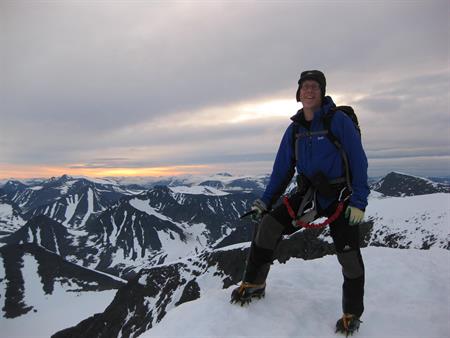
The summit of Kebnekaise at 02:00 (2016-07-05). Photo by Peter Stone.
Click here for larger-size photo. | | Summary Total Data | | Total Elevation Gain: | 5416 ft / 1650 m | | Route: | East Route (Östra Leden) | | Trailhead: | Nikkaluokta 1539 ft / 469 m | | Grade/Class: | YDS 3, Alpine F | | Quality: | 8 (on a subjective 1-10 scale) | | Route Conditions: | Maintained Trail, Unmaintained Trail, Stream Ford, Snow on Ground, Scramble, Exposed Scramble, Snow Climb, Glacier Climb | | Gear Used: | Ice Axe, Crampons, Tent Camp | | Weather: | Pleasant, Calm, Partly Cloudy
Heavy rain on walk-out |
This page has been served 2690 times since 2005-01-15.
|